Back Upper East Side AST اوپر ایست سید AZB Upper East Side Catalan Upper East Side Czech Upper East Side Danish Upper East Side German Upper East Side English Upper East Side Esperanto Upper East Side Estonian Upper East Side Basque
Distrito histórico de Upper East Side | ||
|---|---|---|
| Registro Nacional de Lugares Históricos | ||
| Distrito Histórico | ||
| Hito Histórico de Nueva York | ||
 | ||
| Ubicación | ||
| Coordenadas | 40°46′09″N 73°57′56″O / 40.769166666667, -73.965555555556 | |
| Ubicación |
Nueva York | |
| Condado (s) | Nueva York | |
| Datos generales | ||
| Administración | Local | |
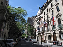
El Upper East Side, a veces abreviado como UES, es un vecindario en el distrito de Manhattan, Nueva York (Estados Unidos). Está delimitado por la Calle 96 al norte, el East River al oriente, la Calle 59 al sur y Central Park /Quinta Avenida hacia el occidente.[1] El área incorpora varios vecindarios más pequeños, incluidos Lenox Hill, Carnegie Hill y Yorkville. Una vez conocido como el Silk Stocking District,[2] ha sido durante mucho tiempo uno de los barrios más prósperos de la ciudad de Nueva York.[3]
El Upper East Side es parte del distrito comunitario 8 de Manhattan y sus códigos ZIP principales son 10021, 10028, 10065, 10075 y 10128. Está patrullado por el Distrito 19 del Departamento de Policía de Nueva York.
- ↑ Gronowicz, Anthony. "Upper East Side" in Jackson, Kenneth T., ed. (2010). The Encyclopedia of New York City (2nd ed.). New Haven: Yale University Press. p. 1352. ISBN 978-0-300-11465-2.
- ↑ The City Review Upper East Side, the Silk Stocking District
- ↑ Plitt, Amy. "The richest neighborhoods in New York City; Where do the wealthiest New Yorkers live? The answers may surprise you (or not)", Curbed New York, June 27, 2017. Accessed September 3, 2017. "That the Upper East Side is No. 1 should come as no surprise, given the concentration of wealth found along the westernmost border of the neighborhood (i.e., Museum Mile and the Gold Coast)."
